GTU's Earthquake Maps
February 27, 2023
Prof. Dr. Taşkin Kavzoğlu, Faculty Member at the Department of Geomatics Engineering at GTU presented the results of the studies conducted at the GTU Geodesy Program and the Advanced Remote Sensing Laboratory during the "February 2023 Eastern Anatolian Fault Line Earthquakes Assessment Meeting".
The online meeting was attended by Prof. Dr. Mustafa Şentop, the Chair of the Turkish Grand National Assembly; Mehmet Fatih Kacir, the Deputy Minister of Industry and Technology; and Prof. Dr. Hasan Mandal, TÜBİTAK President; and Prof. Dr. Muzaffer Şeker, TÜBA President, to support scientific research.
Prof. Dr. Taşkın Kavzoğlu participated in the "February 2023 Eastern Anatolian Fault Line Earthquakes Assessment Meeting" organized by TÜBA. During the meeting, he delivered a talk titled "Analysis of the 6 February 2023 Earthquakes Using Geodetic and Remote Sensing Techniques". In his presentation, Prof. Kavzoğlu shared the results of the studies conducted at the GTU Geodesy Program and the Advanced Remote Sensing Laboratory.
As a result of geodetic assessments, the 24-hour data with 30-second observation intervals of the 10 TUSAGA-AKTIF GNSS stations in the region, which were active before the earthquake, were solved using NASA JPL's GipsyX/RTGx GNSS PPP software for one day before (05 February 2023) and after (07 February 2023) the earthquake. The horizontal displacement vectors were obtained by subtracting the differences between these solutions, and they are shown in Figure 1 below. When the displacement values at GNSS stations near the earthquake epicenters were examined (covering both earthquakes), it was observed that there was a movement of 4.67 meters westward at EKZ1 station, 0.40 meters northeastward at ANTE station, and 0.35 meters northwestward at TUF1 station.
Sentinel-2 satellite images, which are provided to users by the European Space Agency free of charge, offer the possibility of imaging approximately 10,000 km2 of the Earth's surface in a single frame at 5-day intervals. It is used intensively, particularly for post-disaster damage assessment and change analysis, due to its significant advantages. Therefore, Sentinel-2 images were used to quickly visualize earthquake-related changes over a large area after the two earthquakes centered in Kahramanmaraş. The Sentinel-2 images obtained before the earthquake (25 January 2023) and after the earthquake (09 February 2023) were used to quickly visualize the areas of change using different band combinations (Figure 2). It was determined that the changes observed in residential areas were related to structures that were completely destroyed or severely damaged as a result of the earthquake. As a result of these analyzes, the areas with the most damage in residential areas were mapped quickly by province, district, and neighborhood.
Figure 1. Horizontal Motion Vectors at 10 GNSS Points in the Earthquake Zone:
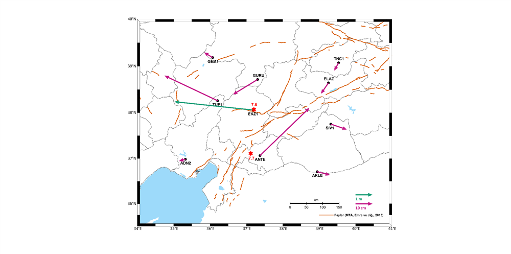
Figure 2. Damage Assessment Analysis for Antakya from Sentinel-2 Images:
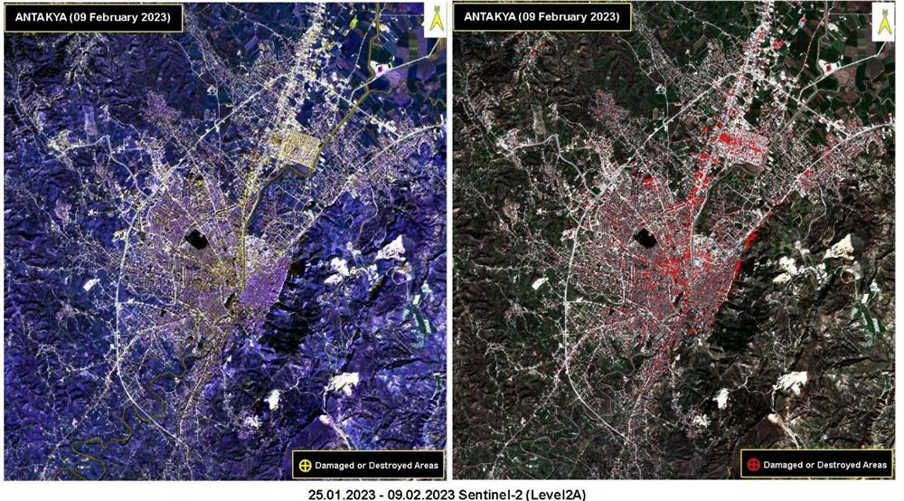
Figure 3: Earthquake Impact Analysis with Synthetic Aperture Radar Satellite Technologies
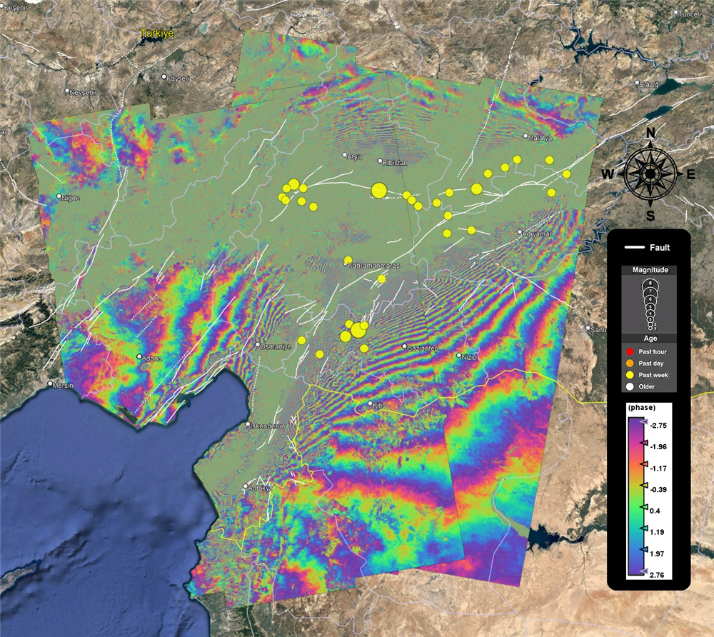
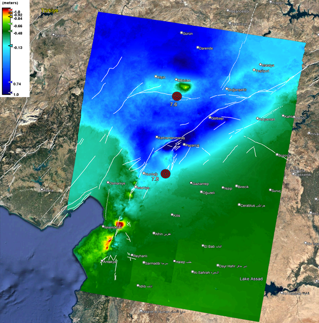
Figure 4. Vertical Displacement Map